Page updated 2. November 2020 - no further data updates
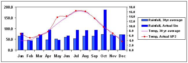
This page carries a chart of monthly rainfall and average temperature during the year to date, the current year's commentary, and data for previous years at the Acton Bridge weather station. Actual rainfall is from a 5-inch gauge, whereas the temperature record is from the Davis VP2.
After 12 years of recording and placing our meteorological data on line, we have had to retire the Davis VP2 Weather Station owing to a relocation. We're sorry that we were not able to complete Calendar 2020; October is our last recorded month.
Here are links to our Monthly Statistics Page ;
Back to Meteo Index Page
October 2020 started off with an exceptionally wet spell, 57mm (more than the whole of September) falling in a 24 hour period over the 3rd and 4th. This is by far the greatest 24-hour rainfall during our 11 years of measurements, and the Met Office also declared 3. October to be the wettest day in its UK records dating back to 1891. By the end of the first week we'd had 112mm, which is more than our average for any whole month of the year. See Met Office Press Release. The remainder of the month was less spectacular but still very wet, with a total for October of 181mm, the wettest month (just beating June 2020) that we have ever recorded in our 12-year measurements with the inherently accurate 5" gauge. After that, the temperature seems rather academic, but the average was 10.2°C, 0.6° below our average and only the second month this year which has been cooler than the norm.
September recorded a near-normal temperature of 13.6°C with a maximum of 27.6 on the 15th, and no frost. Rainfall was very low at 38.3mm (just half our 11-year average) but this was concentrated in two events, at the beginning and end of the month. In between these, there were many rain-free days, and none in double figures.
August was, overall, slightly mild and extremely wet, but was a "month of two halves". The first half was very mild and dry, with a high of 30.9° on the 12th, a new August record for us, but a cooler and much wetter second half led to a mean temperature of 16.8°C, nearly a degree above our norm. The rain got going in the second half, leading to 132mm and (again) beating our previous August record. There were several stormy passages, with Storm Francis dumping over two inches of rain in its three days, including 34.8mm (our second highest ever daily figure) and an exceptional rate of 548.6 mm/hr on the 25th. The year to date is now 25% above our long-term average to August. It was also windy, gusts bringing down tree limbs in our orchard.
July was cool and wet to start with, but warmed up later in the month to an average of 15.3°C, being 1.4° below our long-term average (the first to be so this year), despite a couple of very warm days at the end, including a high of 32.4° on the 31st. This (just) made a new temperature record for us, and was widely reported as such elsewhere in England. Rainfall was 82.8mm, a little below average, though it was mainly concentrated at the beginning and end of the month.
June was just 0.3° above average for temperature, at 15.2°C, with a max of 29.9°C on the 24th, and no frost, completing a pattern of every month of 2020 so far being at or above our long-term average for temperature. On the other hand, June was extraordinarily wet - with 180.5mm, it was wetter than our previous record June of 2012 (146.7mm), and, on our 5" rain gauge, the wettest month we have ever recorded since January 2009, well above December 2012 (168.4mm), though the VP2 tipping bucket gauge had recorded 187.6mm in October 2008, before we had the inherently accurate copper 5" gauge. For reference, 180.5mm is two and a half times our June average, and more than 22 times May's rainfall! The media had warned of "thunderstorms and torrential downpours leading to local flooding", and that's what we got, with short-term rain rates of over 200mm/hr on several days. June's exceptional rainfall has brought us sharply back to 22% above our norm for the first half of the year.
May was mild (the fifth month this year at or above our long-term norm) at 13°C, with a high of 26.8° on the 20th; and very sunny, though the earlier part was quite cool. The Met Office reported that it had been the sunniest spring on record. There was an unexpected frost of -1.4°C on the 14th. May was also extremely dry, with just 8mm of rainfall, half of that right at the beginning, and with only three further days recording significant precipitation. Consequently, we are now some 7% below our ten-year average rainfall for the year to date.
April was mild, and very dry, with a good deal of warm sunshine, very welcome during the first full month of the CoViD-19 pandemic "lock-down". The mean temperature of 10.5°C being 1.5° above our long-term average, the year to date is also now 1.5° above it. There was one mild frost. Until the last few days of the month, rainfall had been exceptionally low; in fact, until the 28th there had been only about 6mm since the 18th of March. The last three days delivered 16mm, taking the total to 20.7mm, but still only 40% of normal, in what is typically our driest month of the year. Despite this, February's deluge means 2020 is, so far, 12% wetter than normal.
March was a much quieter month, with good spells of warm, sunny weather towards the latter part, a high of 18.2° on the 25th, and no rain recorded from the 18th to the 30th. Overall, the temperature was close to our average at 6.6°C and rainfall relatively low at 44.6mm, only one day (the 9th, just) reaching double figures. There were six mild frosts.
February - Storms Ciara, Dennis and then Jorge led to widespread flooding, and very high winds. We experienced exceptional rainfall of 152mm in February, almost three times our 11-year average of 55.3mm, in what is usually a relatively dry month; the Met Office announced that it had been the UK's wettest February on record. The temperature was more than a degree above average at 6.2°C; there were (again) three slight frosts.
We have updated our monthly statistics page with "record" and "normal" data for temperature and rainfall.
January 2020 was very mild, at 6.4°C being nearly 2° above our average; and relatively dry, with 64.6mm of rain. There were three mild frosts, and it was also quite windy mid-month.
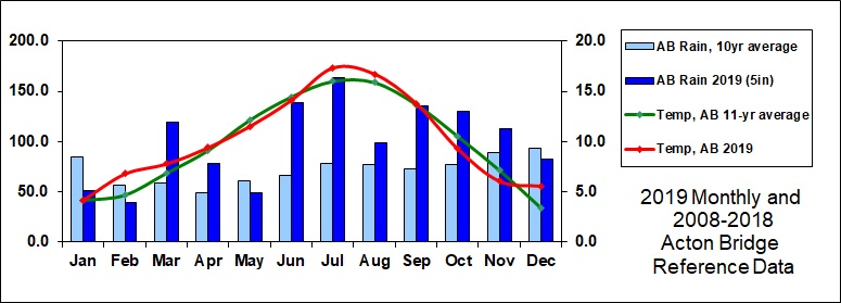
December 2019 was very mild, at 5.6°C, 2,2° above our 11-year average, with only mild frosts, the coldest being -3.6°C on the 2nd. The month was slightly drier than average with 82.7mm, but since this was the first "dry" month since May, and only the fourth this year, the total for 2019 was a remarkable 10-year record of 1,199.6mm of rainfall, even higher than our previous 2012 record of 1,156mm.
November was again a cool month, averaging 6.1°C, 1.0 degrees below our norm. There were a few slight frosts, the hardest being -4.1°C on the 30th. Rainfall of 113.1mm was 27% above normal, and as it was the sixth wet month in a row (and the 8th out of 11 this year), 2019 is likely to be the wettest year in our ten-year record.
October was a degree or so below average for temperature, at 9.3°C, with just a couple of very slight frosts. It was very wet, with 129.7mm of rain, 69% above our ten-year averages for October. This is the fifth wetter-than-average month in a row, and with 1,003.8mm of rainfall recorded so far, it is already the second-wettest year in our ten-year record (2012 having 1,156mm), with two months to go. About 47mm of rain over the weekend of the 25th-26th led to extensive flooding in the Weaver Valley, with boats dragged from moorings and jamming against the bridge and sluice at Dutton Locks, which were over-topped by floodwater.
September was average for temperature, at 13.8°C, but extremely wet, with 135.8mm of rain, most of it falling in the last week or so of the month. This is 87% above our ten-year averages for September, making it the fourth wetter-than-average month in a row, though by means a record - September 2012 measured 167.9mm (and 2012 ended up being a very wet year), though 2019 is already 45% wetter than our 10-year mean to September.
August was mild and wet. Our mean temperature of 16.7°C was 0.8° above average, while rainfall at 99mm, including some heavy downpours, was 28% above our ten-year norm, and the third month in a row, and fifth out of eight so far this year, wetter than our average. Unsurprisingly, our 8-month year-to-date rainfall of 738mm is 39% above our 531mm ten-year figure. On the upside, perhaps, we recorded a high temperature of 30.3°C on the 25th; an 11-year August record here, and conveniently on a Bank Holiday weekend.
July was just a little above average for temperature, overall, at 17.3°C, though we saw an 11-year record for our station of 32.3°C on the 25th. It was exceptionally wet, 163.7 mm being more than double our ten-year figure for July, and a 10-year record for the month. The first half of the month was very dry but from the 19th onwards there were six days with double figures of millimetres, the 19th itself with 34.2mm and consequent local flooding.
June was about average for temperature, overall, at 14.1°C, but exceptionally wet, 138mm being more than double our ten-year figure for June. Even this was less than our June record of 146.7mm in 2012, but in stark contrast to the exceptionally dry June 2018, with only 4.6mm. However, most of the 2019 June's rain fell in the second week, and the end of the month was dry and very warm, 29.1° being recorded on the 29th, with a night-time minimum of 15.6°. Our monthly statistics page has further comparisons.
May was slightly cool, the average of 11.5°C being 0.6° below our norm; there was no frost. It was also slightly dry, 49.3mm being 19% below our ten-year figure for May. There was a period of over two weeks (11th to 26th) with only 3mm recorded, and no day reached double figures.
April was about average for temperature, at 9.4°C, but very wet. For the week of the 17th to the 24th, temperature maxima were in the 20s, with 25.8°C on the 20th. However, other parts of the month were cool; there were only a few, slight, frosts. Almost all the rain fell in the first few days and then the last week, with an extraordinarily dry period (for April) from the 5th to the 23rd, when only 1mm was recorded over nearly three weeks. In contrast, 50mm (two inches) fell on the 26th (13mm) to 27th (37mm), for a monthly total of 78.4 mm, 60% above our long-term average.
March was mild and extremely wet, the first half of the month recording 111mm of rainfall, almost twice our March monthly average, and indeed higher than our average for any month, by the 16th, on which day 17.2mm of rain fell. The second half was very dry, so the total ended up at 119mm. The mean temperature of 7.8°C was one degree above our 11-year norm; there were several days with very mild maxima, such as 20°C on the 20th and 17°C on the 28th. We had just two very mild frosts on the 28th and 29th, the former showing a large daily range. The middle of the month was very windy - our anemometer cable was jury-rigged in anticipation of this, and recorded a gust of almost 42 knots (say 48 mph, 77 kph) on the 13th.
February was very mild, at 6.8°C some 2 degrees above our 11-year norm; and dry, with 39.5mm of rain, 32% down on average, and even drier than January. Temperature records were broken in several parts of the UK, our 19.5° being our own February record, by some margin, and the mean equalling our 2011 figure. There were many very sunny days with spring-like conditions.
January 2019 was almost exactly normal for mean temperature, at 4.1°C, and the first half was exceptionally dry, with only 5mm, but the second half was more typical and the month's total of 51mm was some 61% of our long-term average. There were some sharp frosts towards the end of the month, -5.6°C being recorded on the 31st.
We'll add some annual summaries in due course.
Simplified to remove Met Office historical data, as we have now accumulated our own baselines of ten years for temperature and nine for rainfall (since the 5 inch gauge was installed and calibrated). For previous years, below, rainfall reference values were the averages of Shawbury and Manchester (Woodford) Met Office stations for the 30 year period 1981 to 2010; and our own records, from 2009 to 2016.
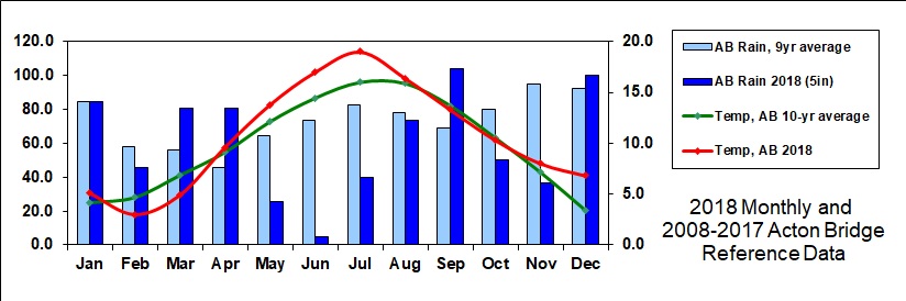
December 2018 was very mild, at 6.8°C being 3.4° above average, and a second significantly milder month since the summer. It was rather wet, with 99.8 mm of rain, 8% above our norm, making it the second wettest of the year, notably with 24mm (nearly an inch) of rain on the 5th and 10mm on the 23rd. There was only one frost to speak of, -1.8°C on the 14th.
November was mild, about 1° above average at 8.0°C, and the first significantly milder month since the summer. It was also dry, with only 36.3 mm of rain, less than half our norm, and almost half of that fell in the last few days of the month, when it was also very windy. There was only one frost to speak of.
October was about average for temperature (10.5 °C) and relatively dry, with only 45.4 mm, 57% of our 9-year October average. After a very warm spell in the second week, there were three slight frosts at the end of the month, the first of the season.
September was only slightly below average temperature at 13.3°C, but very wet with 104mm, 51% above our nine-year mean rainfall for that month, though nowhere near our exceptional September 2017.
August was a reversion to more normal weather, our mean temperature of 16.4°C being only 0.5° above average, while rainfall of 73.5mm was 94% of our nine-year norm.
July was another very warm month, our mean of 19.0°C being exactly 3° above average. It was also quite dry, at 40mm being only half that in our 9-year sequence for July. The VP2 recorded 44.6mm, so it's possible that there was some evaporation from the 5" gauge on unattended days, but the month was a dry one, either way.
June was very warm and exceptionally dry, with a great deal of sunshine. Our mean temperature of 17.0°C was 2.6° above the norm, with a maximum of 31.9°C on the 26th, which is a 10-year record for our station. Rainfall at only 4.6mm (though 5.4mm on the VP2 gauge) was only 8% of our 9-year average - there were only seven days with any recorded rain, and only one with more than 2mm, on the 16th.
May was warm (13.8°C, 1.7° above our norm) and dry, 26mm being only 47% of our 9-year average.
April began very cold and wet, but by the end of the month, largely as a result of extremely warm few days around the 19th, the average temperature was 0.5°C above our 10-year norm. There was no frost. Rainfall at 80.6mm was 77% above normal, almost exactly the same as for March.
March was another cold month, at 4.9°C compared with our mean of 6.8°, and with several frosts, the hardest being -5.4° in the 1st. It was also very wet, 80.9mm being 44% above our average for March.
February was cold, our 3.0°C being 1.7° below average; and rather dry, at 45.5mm. There was modest snowfall during the last few days, and a frost of -6.8°C on the 28th, which remained below freezing all day.
January 2018 was mild, our 5.1°C being exactly one degree above average, and normal for rainfall at 84.5mm. There was a frost of -3.6°C on the 8th, and a wind gust of 47 knots (say 54 mph) on the 18th caused local damage to property and trees.

2017 Commentary
December was, once again, rather wet, with 107.1mm of rainfall; and mild, at 4.9°C, despite a low of -5.7°C on the 12th, the first significant frost of the winter.
November was another rather wet month, but normal for temperature at 7.2°C; there were only a few, mild, frosts. Rainfall of 102.8mm was 10% above our norm, with three days in double-digit millimetres; so far, every month this year apart from April and May has been wetter than average.
October was another wet month, but much milder than average at 12.3°C, nearly 2° above our norm. About half the night-time minima remained in double figures, and there was only one, very mild, frost, on the 30th. Rainfall of 95mm was 19% up, the fifth consecutive "wet" month, with about 19mm recorded on the 4th and the 19th.
September was again slightly cooler than average (by 0.5°C) and extremely wet (141mm, more than double our norm). This was our wettest recorded month since October 2013, and our wettest September since 2012. There were six days with double-digit rainfall, and peak rain rates of around 80mm/hr on the 10th and 13th.
August was slightly cooler (by 0.5°C, the first month this year to be so) and wetter than average (92mm compared to 76mm). There was a heavy downpour of 29mm on the 8th with a peak rain rate over 100mm/hr ; in contrast, the last ten days of the month were very dry.
July was about average for temperature at 16.4°C, and for rainfall, at 80.6mm. The first half of the month was generally very dry, at 20mm, even with a downpour on the 10th/11th; the second half was much wetter, with three significant rain events. It was yet another month at least as warm as our average.
June was warm and wet, at 15.9°C some 1.5° above our average, and the rainfall of 83mm was 15% above the norm. There were only two days with double-digit rain (in mm), the higher being of 24mm on the 10th. So far this year every month has been warmer than, or as warm as, our eight-year average.
May was warm and very dry, averaging 13.4°C, 1.3° above the norm, and with only 35mm of rainfall, mostly in the second half. We recorded no rain at all for ten days from the 2nd to the 11th, and for six consecutive days later in the month. There was no frost.
April was exactly on the average for temperature, but very dry. The mean temperature was 9.2°C, with only one, very slight, frost. Rainfall of 25.6mm was just half our April average, and over half of this fell on the 14th and 16th, the first two weeks being almost rain-free.
March was mild and very wet. The mean temperature of 8.3°C was 1.5° above average, with only one frost, and three remarkably mild minima in double figures. Rainfall of 95mm was 77% above average, most of it falling in the first and third weeks.
February's weather was dominated by Storm Doris, which swept through on 23rd. We recorded a gust of 56.5 knots (say 65 mph), bringing down a large pear tree which had stood for a century. Until the last week of the month it had been mild, with barely a frost, and very dry, but the remainder was wet and very blustery, though still mild. The temperature of 6.3°C was 1.6° above average, and the rainfall 14% higher.
January 2017 was about average for temperature and rainfall, though very windy at times, with a gust of 41.7 knots (say 48MPH) on the 11th.

2016 Commentary
December 2016 was very mild, nearly 3° above average, and rather dry, though there was a torrential downpour on the 23rd with a rain rate of 206mm per hour, and wind gusts of 32 knots, as the southern margin of Storm Barbara swept through. Christmas Day was exceptionally balmy, with an average of 11.3°C - compare this with Christmas Day 2010, when the average was minus 9.8°C.
November was very cold and very wet, the mean temperature of 4.9°C being two degrees below our long-term average, and with 113mm of rain some 24% above the norm. It was the first "cold" month since April, and almost the coldest November in our 9-year record. The temperature only just got above freezing on the 26th, and the later part of the month was also virtually windless on several days.
October recorded a normal temperature, but was very dry, with barely a third of average rainfall, making it the driest October in our nine-year record. It was exceptionally dry in the first half, with only 5mm of rain by the 15th. There were a few wet days after that, but little more than dew for the rest of the month, and no frost.
September was mild at 15.7°C (2°C above average) and a little below average for rainfall, despite an exceptionally heavy downpour on the 25th, with a rain rate briefly exceeding 150mm/hour. Twelve days enjoyed maxima of 20°C or above, while the night of the 6th had a minimum of 19°C.
August was slightly mild and dry, the mean temperature being about a degree above average, and the rainfall some 20% lower, despite there being only 18 days without significant precipitation.
July was slightly mild (0.6° above average) and rather dry at 62mm, 73% of our long-term mean. However, two thirds of the rain fell in the first half (despite a downpour on the 28th), which was also rather cool. The hottest day of the year so far was the 19th with 30.7°C.
June was mild (1.1° above average) and very wet at 117mm, 79% above our long-term mean. 32mm fell on the 14th and there were several other heavy downpours. June completed a very wet first half of the year, with 537mm, 48% above our long term average.
May was slightly milder than average (12.6°C compared with 12.1°C, with a max of 25°C on the 8th) and no frost. It was rather dry (48.9mm compared with 72mm) with only one day in double figures of millimetres.
April was cool and very wet, 88.5mm of rain being 42% above our average, though there was a completely dry week from the 17th. Mean temperature at 7.5°C was 1.6° below average, and there were two mild frosts.
March was cool and wet; almost all the 83.7mm of rain fell in the first and last weeks, with a completely dry fortnight in between. Mean temperature at 5.9°C was a degree below average, and rainfall well above. There were a few mild frosts, the minimum being -3.3°C on the 8th.
February started very mild (and very wet), but settled towards the average later, so that the mean temperature of 4.7°C matched our long-term figure, and there were several frosts (-4.4°C on the 24th). Rainfall of 70mm was 27% above average, but half of this fell in the first week.
January 2016 was another mild and very wet month, our mean temperature of 5.7°C being 1.6° above average, and there was only one significant frost (-3.3°C on the 16th). Rainfall of 128mm was 63% up.
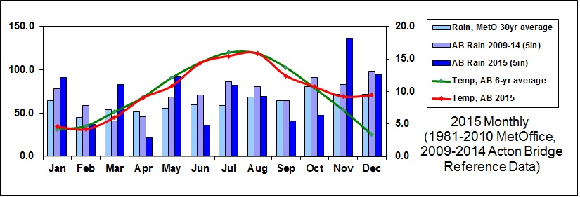
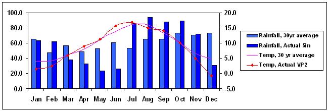
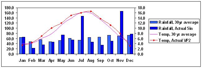
The Charts above and below show temperatures (red) at Acton Bridge each month during the current year-to-date and the previous year (2015), compared with our own 6-year 2009-2014 averages (green); and monthly rainfall at Acton Bridge (dark blue), compared with our own 6-year 2009-2014 rainfall readings (mauve) and the Met Office 30-year 1981-2010 averages for Shawbury and Manchester (light blue). Our own 5-year temperature readings are so similar to the MetOffice ones that the latter have been omitted for clarity.
2015 Commentary
December 2015 was extraordinarily mild, especially in the first half, and quite wet, though Acton bridge escaped the serious flooding elsewhere in the North West of England. The whole-month average of 9.4°C was (probably without precedent) a full six degrees above the norm, and there was no frost to speak of. Five nights had double-figure Celsius minima. It was windy, with a gust of 44.3 knots (51 mph) on the 30th which felled one of our old pear trees.
November 2015 was exceptionally mild in the first half, averaging 12°C at times, and very wet. The whole-month average of 9.2°C was (most unusually) a full two degrees above the norm, the first month this year to be warmer than our average, and there were mild frosts in the third week. A very high rain rate of 96mm per hour was recorded at 5pm on Sunday 8th. Double figures of millimetres of rain fell on five days, and there were only a few days without some rain. It was windy, with a gust of 43.5 knots (50 mph) on the 29th.
October 2015 was about average for temperature and relatively dry. At 10.7°C the mean temperature was just 0.2° above our six-year figure, the first "warmer" month since January, with some mild nights and no frost. The 47.3mm of rainfall recorded, in what is usually our wettest month, was 41% down, and (as in September) there was only one day (the 21st) making double figures.
September 2015 was cool and dry. At 12.4°C the mean temperature was 1.3° below our six-year average, and the 40.6mm of rainfall recorded was 37% down, only one day (the 12th) making double figures. This is the eighth month in a row which has been either cooler, or no warmer, than average.
August 2015 was a close match to our long-term average, again owing to mild nights with little diurnal variation and a maximum of 24.7°C, but (yet again) the perception will have been of a dull and damp month. We had 18 "rain days" of greater than 0.2mm, though only two reached double figures of millimetres of rainfall, most impressively on the 14th, with 20.6mm recorded,
July 2015 was cooler than average, and wetter. There was no frost. The perception was of a dull and cold month, with a lot of rain, but in fact the average temperature was only 0.6°C below normal, perhaps owing to mild nights with little diurnal variation. Much of the rainfall was in only two periods, especially the 5th and the 29th, the only days to reach double figures of millimetres, and continues the pattern of alternate wet and dry months. In contrast to 2014, and with the exception of January, no month this year has been warmer than our average. Note that this month's and subsequent charts include 2014 Acton Bridge rainfall data in the mauve (middle) six-year average columns.
June 2015 was cool to start with but a last-week heat-wave restored the average temperature to our expected norm at 14.3°C. There was no frost. Rainfall was generally low, the exception being a heavy downpour on the first of the month, the only day to reach double figures of millimetres.
May 2015 was cool and very wet, with little sunshine. The average was 10.8°C, more than a degree below our norm, though there was only one very mild frost. Although there were many dry days, heavy rain fell in four principal events spaced through the month, adding up to 92mm, 44% above our normal May.
April 2015 was average for temperature, sunny, and very dry, 21 days each having no more than 0.2 mm (a light overnight dew, if that). Only the first and last few days produced significant rainfall. There were three mild frosts, partly because it was also quite windy.
March 2015 was cool and very wet, though the majority of the rain fell in the second half, especially during the last week, with 57mm in five days. The mean temperature of 6.0°C was 0.8° below average, and the rainfall of 82.6mm more than double our 2008 to 2013 March averages (usually our driest month). It was another breezy month, with a gust of 47 knots (54mph) on the 31st.
February 2015 was about average for temperature overall, though cold at the start and relatively mild at the end ; and rather dry, particularly the first half of the month, in which we recorded only 3mm of rain. There were only slight frosts. It was also quite windy (though less so than January), with gust of 34 knots (39mph) on the 24th.
January 2015 was mild, and quite wet, 36% above our average at 90mm and there was some precipitation almost every day. Snow fell on two occasions but only lay for a day or so. The early part of the month was at least two degrees above normal, though this settled back to a chilly end, making a mean of 4.6°C, which is 0.5° up. There were frequent but only slight frosts. It was also windy, with gust of 48 knots (55mph) on the 28th.
The Chart above shows temperatures (red) at Acton Bridge each month during the current year (2014), compared with our own 5-year 2009-2013 averages (green); and monthly rainfall at Acton Bridge (dark blue), compared with our own 5-year 2009-2013 rainfall readings (mauve) and the Met Office 30-year 1981-2010 averages for Shawbury and Manchester (light blue). Our own 5-year temperature readings are so similar to the MetOffice ones that the latter have been omitted for clarity.
December 2014 was again a very mild month, its mean of 5.2°C being 1.8° above the average. It was also quite wet, with 109mm of rain, 14% above our average for December. Although there were 8 nights with frost (the lowest at -3.3°C) there were also some remarkably high minima, for example 11.9°C on the 22nd. There were some strong winds, including a gust of 40 knots (46mph) on the 10th. The year 2014 overall was 0.9° warmer than average (only August being cooler) and 5% wetter than our five-year mean.
November 2014 was yet another month milder (by 0.9°C) than the long-term average, particularly in the early part. There was no frost. Rainfall was below average, though there were relatively few entirely dry days. It was typically autumnal, foggy and dull, though there were some windy days, with a gust of 35 knots (40mph) on the 13th.
October 2014 was again mild, at 11.8°C, more than a degree above the mean, and about average for rainfall, though only seven days recorded 0.2mm or less, so it felt cloudy and damp. There was no frost, but there were strong winds, especially on the 21st with a gust of 43.5 knots (~50mph, ~80kph).
September 2014 was mild at 14.4°C (0.7°C above average), and, as the chart above shows, extraordinarily dry, with only 10.1mm of rain. This was by far the lowest we've measured for any month, and records were set throughout the UK. The temperature profile was characterised by mild nights, eleven in double figures, with the coolest being 5.1°C. After the 2nd, we had a run of 16 days with no rain at all, then a short showery period with 7.2mm over two days. There were only seven "rain" days (over 0.2mm) in the month, whereas August had just the same number of "rain-free" days.
August 2014 was cool, at 14.7°C, more than a degree below the mean (the first month below average since December 2013), and extremely wet. It was cloudy for much of the month, and there were several significant downpours, with 20mm on the 1st and a full inch (25mm) on the 10th leading to a total of 125mm, 80% above the norm. There were only seven rain-free days.
July was very warm, some 1.7°C above the mean, and relatively dry, only half the days having any precipitation. After a rain storm of 17.2mm on the 19th, there was only a further 1mm in the month, leading to parched lawns. The high mean temperature of 17.7°C, the second highest in our seven-year log (after July 2013) was largely attributable to very mild nights, only five having single-figure minima. This was the eighth consecutive month (including December 2013) which has been warmer than our average.
June was mild and slightly dry overall, though the rainfall was concentrated around the 7th and the 27th, only one millimetre being recorded between the 16th and 26th. The mean temperature of 15.4°C was one degree above average, and the rainfall about 80% of our norm.
May was just above average for temperature at 12.6°C, but very wet, with 93mm of rainfall, 46% above our five-year mean and 69% above the Met Office 30-year 1981-2010 averages for Shawbury and Manchester. Although there were many dry days, there were prolonged and sometimes heavy storms from the 8th and the 22nd. There was no frost. This is the sixth consecutive month which has been warmer than our average.
April was slightly mild, with the mean temperature of 10.4°C being 1.4° above our long-term average, and rainfall of 49mm typical for the month. Unusually for April, there was no frost, and less than 1mm of rain was recorded between the 9th and the 21st.
March was a "normal" month in Acton Bridge, with the mean temperature of 7.2°C and rainfall of 54mm typical for the month. Six nights recorded a mild frost, the lowest being -2.6°C on the 11th (the coldest of the year to date) ; the high point was 19.5°C on the 30th. There were further strong winds, with a gust of 35 knots on the 18th bringing down another of our trees.
February was mild, especially during the second half, and very wet, though nowhere near the levels of January. The mean temperature of 6.1°C was 1.4°C above average, and rainfall at 84mm some 58% above our norm. The temperature was remarkably even, with only a trivial frost of -0.1°C on the 10th, and a max of 12.3°C on the 23rd (when the overnight minimum was a balmy 7.9°C). It was very windy, with a gust of 47 knots (54 mph, 86kmh) on the 12th felling three trees in our orchard, and leaving much of the village without electricity for several hours.
Our meteorological "Winter" (Dec-Feb) recorded only six, very mild, frosts, with a quarter minimum of -1.6°C. This is very different from the harsh winters of 2009-10 and 2010-11 (see our statistics page).
January 2014 was mild, and exceptionally wet. The early part of the month was at least two degrees above normal, though this settled back to a mean of 5.4°C, which is 1.2° up. There were only three, very slight, frosts. Our rainfall of 133.5mm was our wettest recorded January ever, almost exactly twice our 5-year average, and there was only one day with no rain at all. We had a significant thunderstorm on the 25th, with heavy, driving hail; and it was also windy. Several parts of the UK broke rainfall records, and suffered extensive and prolonged flooding.
The Chart above shows temperatures (red) at Acton Bridge each month during 2013, compared with our own 5-year 2008-2012 averages (green); and monthly rainfall at Acton Bridge (dark blue), compared with our own 5-year 2008-2012 rainfall readings (mauve) and the Met Office 30-year 1981-2010 averages for Shawbury and Manchester (light blue). Our own 5-year temperature readings are so similar to the MetOffice ones that the latter have been omitted for clarity.
December 2013 was very mild - the mean temperature of 6.5°C was 3.1 degrees above our five-year average, and warmer than November. Rainfall at 69mm was well below our mean, though most of this fell towards the end of the month, when it was also very windy. There were only two nights with frost, neither severe.
November 2013 was cold, and about average for rainfall. The mean temperature of 6.1°C was 1 degree below average, and rain at 69mm was just slightly below the Met Office 5-year average, but only 70% of our last five years' mean for the month. The last week was almost completely dry, and there were four nights with an air frost.
October 2013 was mild, and exceptionally wet at 158mm, 61% above our average (and October is our wettest month). The first half of the month was some three degrees warmer than average, with several double-figure night-time minima, though more normal later, which brought the mean to 12.0°C, 1.5° above the long-term figure. There was no frost. Apart from the second week or so, rainfall was consistently high, and there were several severe downpours. It was also quite windy, though Cheshire escaped the damaging "St Jude" storm of the 27th-28th in the south of England and Wales.
September 2013 was slightly cool and dry, with an average temperature of 13.3°C, 0.4°C below the 30-year norm, and rainfall of 55mm, 15% below average. The first and third weeks were quite warm (max 25°C on the 4th, 23°C on the 22nd), while most of the rain fell in the middle of the month.
August 2013 was comparatively warm and dry, with an average temperature of 16.6°C, 0.7°C above the 30-year norm, and rainfall of 53mm, 67% of the average.
July 2013 was the first month since March 2012 to be significantly warmer than average, by some 2.5 degrees. It was hot (30.1°C on the 18th) and exceptionally dry until the last few days, when the drought broke on the 27th with over 30mm of rain overnight, and thunderstorms on the 29th produced a rate of 120mm/h at Acton Bridge. The final rainfall of 69mm was still only 70% of our local average for July.
June 2013 was the first month this year to be "normal" for temperature and rainfall, though it was not consistent. The first half was very dry, and the rain in the second half came in three defined bursts each a week apart. The mean temperature of 14.1°C was fractionally below our own 5-year average of 14.4°C and the Met Office average of 14.3°C; and rainfall at 66mm was below our norm but above the MetOffice one. The first half of 2013 has been 1.7°C cooler than our mean, and 9% wetter.
May 2013 was cool, yet again, and wet. In fact, we have not recorded any month significantly warmer than average since March 2012. The mean temperature of 10.5°C was a full degree colder than the Met Office average, and rainfall at 81% was 47% above the norm. The Met Office announced that these three months had been the coldest "spring" for 50 years. Over an inch of rain was recorded on the 15th and there was another downpour on the 28th, but there were also many dry days.
April 2013 was cool and extremely dry, probably the driest month in our five year record. The first part of the month was very cold, with frost every night for the first week, and the temperature only approached the seasonal average towards the end. Rainfall was negligible for the first ten days, and only a few showers arrived later with the total under 18mm, about a third of the norm.
March 2013 was exceptionally cold and overall very wet, though the last week was dry. There was only one day (5th) which achieved a double-figure Celsius temperature, while the mean was 2.6°C, nearly four degrees below average and much colder than either February or January, and there were 19 nights with frost, including several hard frosts. Snow fell heavily during the third week of the month.
February 2013 was cold and slightly wet. The first half of the month was mild and very wet, exceeding the long-term average by the 13th. However, apart from some dew, the second half of February was completely without precipitation, and cold, leading to an overall average temperature of 3.3°C, a full degree below the average.
January 2013 was cool and wet. The average temperature of 3.6°C was 0.7 degrees below the long-term average, with a chilly fortnight from about the 13th to the 26th, though the beginning and end of the month were mild. Rainfall at 82.2 mm was 28% above normal, some of it falling as snow.
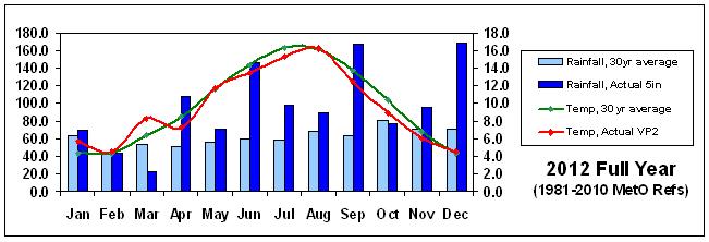
Summary of Rainfall and Temperature at Acton Bridge, 2012
Page updated 4. June 2013, and later amalgamated into whole Charts Series 6. July 2020
In Acton Bridge, the year 2012 was recorded as follows:-
Rainfall (5" gauge) was 1,156mm (172% of the 744mm 30-year Met Office 1981 to 2010 average. The months of April, June, September and December 2012 were exceptionally wet, and the Met Office reported in late December that 2012 had been the wettest year for England since records began.
The Chart shows three rainfall series - lightest blue is the Met Office 30-year averages for Shawbury and Manchester ; the mid-blue is the four-year 2008-2011 averages for the Acton Bridge 5" rain gauge ; and the darkest blue is the 2012 monthly rainfall. The months of April, June, September and December 2012 were exceptionally wet, by either standard. The Met Office reported in late December that 2012 had been the wettest year for England since records began.
Monthly Commentaries for 2012
December 2012 was an exceptionally wet month in Acton Bridge, with 168mm completing an exceptionally wet year of 1,156mm, by far the wettest in the last five years. There were only four dry days, and very little sunshine. Temperatures were low at the start, with three nights' frost and two days when the temperature never rose above zero, but it warmed up at the end of the month with an unusually high minimum of 10.7°C on the 31st.
November 2012 was wet and slightly cool, but the averages belie some sharp contrasts. The middle of the month was mild and dry, but significant storms (causing serious flooding in some areas) followed by frosts changed its character later. The year to date has recorded 47% more rainfall than the MetO thirty-year average would suggest.
October 2012 was rather cool and slightly dry. It was another cloudy month, and so felt colder than the recorded mean of 8.9°C, which is about 1.5°C below average. There was just one frost of -0.3°C on the 27th. Rainfall at 76.3mm was 5% below the mean, mainly falling in three significant events, with the period 18th to 27th almost dry.
September 2012 was rather cool, and exceptionally wet. After a dry start, there were serious storms and flooding in many parts of the country as a very deep depression was trapped over the UK by a kink in the jet stream. Acton Bridge recorded over 100mm of rain in three days (23rd to 25th) with much of this falling in just a few hours onto already-wet ground. The mean temperature was 12.5°C, about 1.2°C below the re-based (1981-2010) MetO 30-year average of 13.7°C ; and rainfall (5 inch gauge) amounted to 168mm, 260% of the 64mm expected, and easily exceeding June's 147mm. This was the sixth "wet" month in a row, bringing the year-to-date to 57% above normal.
August 2012 was about average for temperature at 16.2°C, but rather wet at 31% above normal, the fifth unusually wet month in a row, taking the year to date to 42% above average, and the "summer" quarter of June to August 78% above. An inch of rain fell in a single hour on 5. August, at a rate 128 mm/h, and nearly half an inch in less time on the 15th at a rate of 106 mm/h, giving 45mm by mid-month. As in recent months, the broad averages don't fully represent the experience - mild nights and low daytime maxima gave the impression of a cooler month than it was.
The Met Office has at last published its updated long-term statistical averages, for 1981 to 2010, and these will now be used as our references, taking an average for their stations at Manchester Airport and Shawbury.
July 2012 was again slightly cool, especially to start with, but finished about one degree below the long-term average. As during June, persistent cloud cover produced little diurnal variation, with mild nights and cool maxima, so the perception was of a colder month than the data support. It was another very wet month, the fourth such in a row, with nearly double the typical rainfall, most of it in the first half ; and just one significant dry and sunny spell, during the fourth week. Accumulated rainfall for the year to date is 46% above normal.
June 2012 was slightly cool, especially to start with, but finished about half a degree below the long-term average. Persistent cloud cover produced little diurnal variation, with mild nights and cool maxima, so the perception was of a colder month than the data support. It was exceptionally wet, with more than double the typical rainfall and very few dry days. The first six months of the year delivered 40% more rain than the 30-year average.
May 2012 continued April's cool weather for a couple of weeks, the middle part also being very wet, with 50mm of rain within a week. This was followed by high-summer conditions, with five successive daily maxima around 25°C and no rain at all during the 11-day period 20th to 30th. There was also a short period of unusually high pressure, with the VP2 at Chester showing 1,035.8 mB on 12. May.
April 2012 was cool and extremely wet, in marked contrast to March. The average temperature of 7.2°C was 0.7 degrees cooler than normal, mainly as a result of low daytime maxima rather than cold nights. Remarkably, the mean, maximum and minimum April temperatures were all lower than the equivalents for the previous month. Rainfall was more than double the 30-year average at about 108mm (April is normally quite a dry month in Acton Bridge). Nationally, April 2012 was the wettest, and among the coolest, on record.
March 2012 was generally mild, and at 8.3°C, more than two degrees above average temperature. There was only one frost (-0.6°C on the 6th), and a remarkably warm final week, with three days exceeding 20°C. It was also very dry, at a mere 42% of the long-term average, with only two significant rain events, around the 3rd and the 17th. There was no rain at all from the 18th onwards.
February 2012 was, at 4.5°C, close to the average temperature, and very slightly dry. The first part of the month was cold, with 8 air-frosts in the first 11 nights, but the remainder was mild, with some exceptionally high night-time minima and daytime maxima (such as 9.3°C and 16.9°C on the 23rd), bringing the average back up.
January 2012 was mild and slightly wet. The average temperature of 5.7°C was nearly two degrees above the long-term average, and rainfall at 69.2 mm was 6% above normal. Until late in the month it was very mild, with some remarkably warm night-time minima, but the last week reverted to type. The first week or so was very windy, with a gust of 43.5 kt (50 mph, 80 kph) bringing down trees on the 5th.
Page updated 8. January 2012, and later amalgamated into whole Charts Series 6. July 2020
In Acton Bridge, the year 2011 was recorded as follows:-
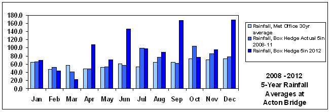
Rainfall (5" gauge) was 760 mm (104% of the 731mm 30-year average) but this belies significant variation within the year. March and April were much drier, whereas February and December were much wetter than average.
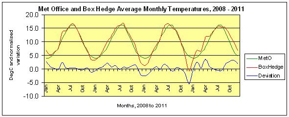
The following charts show the last four years' monthly and annual temperatures plotted (red) against the (repeating) Met Office averages (green), with our recorded deviation from average plotted in blue to the same scale.
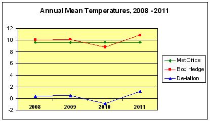
The years 2008 and 2009 were slightly warmer (+0.4° and +0.5° respectively) than average, 2010 was significantly cooler (-0.8°) than average, and 2011 was significantly warmer (+1.2°) than the 30-year average.
December 2011 was very mild and very wet. The average temperature of 6.7°C was exactly two degrees above the long-term average, and rainfall at 133.7 mm was 83% above normal. Only one day (the 18th) recorded a frost, and that was a mere -1.1°C. In contrast, the overall mean temperature for December 2010 was -0.8deg;C.
November 2011 was very mild and dry, the third unusually mild month in a row, completing a very warm and rather dry Autumn. There was only one night with a frost, and the average daily temperature was well into double figures until the last few days of the month, when a cold front came through bringing 30+ knot gusts, hail and 6mm of rain in a couple of hours. This pulled the average down to 9.8°C, still a remarkable 3.3°C above the long-term average. Rainfall at 39.8 mm was only 56% of average.
October 2011 was very mild and rather wetter than average. The mean temperature of 12.8°C was 2.7 degrees higher than the norm, though (as in September) more as a result of mild nights than hot days. The first half of the month was exceptionally warm, however, with a max of 28.2°C on the 1st, and minima generally well into double figures until the 14th, and no frost recorded.
September 2011 was warm and dry, quite a change from the previous four months. The average temperature of 15.1°C was 1.8 degrees higher than average, though more as a result of mild nights than hot days, while rainfall at 31.6mm was less than half the norm. The last few days were however exceptionally warm, with 27.5°C on the 30th. [1. October turned out to be the hottest day of the year, hotter than any day during the summer].
August 2011 was the fourth wet month in a row at Acton Bridge, with 75.1 mm of rain, 16% above average, and making the first eight months 4% wetter than the norm. August was conspicuously cloudy and had 25 "rain days" (0.2mm or more) and two storms, on the 10th and the 26th / 27th. The overall temperature was remarkably steady, with few excursions below 10°C or above 20°C. Because there was only one really hot day (3rd, max 26.4°C), the month felt cool, although it actually averaged 15.4°C, just half a degree below the 30-year norm.
July 2011 was the third wet month in a row at Acton Bridge, with 69.8 mm of rain, 31% above average, and making the first seven months 3% wetter than the norm. Most of the month's rainfall occurred in two brief spells, especially around the 17th with an inch in 24 hours, and the last nine days recorded none at all. Apart from cooler periods associated with the rain, the overall temperature was steady and ended up half a degree below average.
June 2011 was another comparatively wet month at Acton Bridge, with 80.5 mm of rain, 32% above the 30-year average of 60.9mm, bringing the first half of the calendar year to 98% of the norm. Despite a few very warm days towards the end of the month (reaching 27.6°C on the 26th, and 27.9°C on the 27th) the overall temperature was just 0.1°C above average.
May 2011 was comparatively wet month at Acton Bridge, with 69.4 mm of rain, 32% above the 30-year average of 52.5mm. May was also rather mild, averaging 12.1°C, which is 0.7°C above the norm. There was no air frost during the month.
April 2011 was an exceptionally warm month at Acton Bridge, averaging 11.6°C, a remarkable 3.7°C above the norm. Seven days had highs above 20°C, with a maximum of 24.6°C on the 21st, and there was no air frost during the month. April was also very dry, with only 19.9 mm of rain (half of which fell in about one hour on the 22nd), just 41% of the 30-year average of 48.1mm. Twenty-two days recorded no rain at all.
March 2011 was exceptionally dry at Acton Bridge, with only 16.7 mm of rain, half of which fell in the last two days of the month. There were just three days with more than 2mm of rainfall, leading to only 30% of the 30-year average of 56.5mm. March also started quite cold, reversing the pattern of February, until the third week of the month when highs of about 18°C were recorded on a couple of days, and the month as a whole finished 0.5°C above average.
February 2011 was comparatively mild and very wet at Acton Bridge. February is statistically our driest month at 47mm, but we recorded 81mm of rainfall, 70% above average, and higher even than the 30-year average for October, the wettest month of the year here. The mean temperature of 6.8°C was a significant 2.6°C above the norm. The daily mean temperature exceeded 10°C on the 4th, 5th, 6th and 25th, while 20mm of rain fell on the 5th, and there were only six days with no rain at all.
January 2011 was comparatively dry and cool at Acton Bridge, with 56mm of rainfall, 86% of average, and a mean temperature of 3.4°C, 0.6°C lower than average. Only two days (13th & 15th) had mean temperatures in double figures, and only one day (5th) recorded more than 10mm in the 5" gauge.
Page updated 17. March 2011 and 28/6/2020 (degree signs), and later amalgamated into whole Charts Series 6. July 2020
This chart shows monthly rainfall and average temperature during the year 2010 (to date) at the
Acton Bridge weather station. Actual rainfall is from a 5 inch gauge, whereas the temperature record is from the Davis VP2. Reference values are the averages of Shawbury and Manchester (Woodford) Met Office stations for the 30 year period 1970 to 2000.
The first half of December was also very dry, with less than 10mm of rainfall recorded by the 15th, and only 43% of the 30- year average for the entire month. The VP2 tipping bucket was frozen solid for extended periods, and under-read after thawing, jammed by ice. The 5" gauge may have under-read owing to sublimation of snow on unattended days.
In Acton Bridge, the year 2010 was recorded as follows:-
Rainfall (5" gauge) was 704 mm (93% of the 731mm 30-year average) but this belies significant variation within the year. March, April, May and June were much drier, whereas July, August, September and October were much wetter than average.
Page format updated 17. March 2011, and later amalgamated into whole Charts Series 6. July 2020
This chart shows monthly rainfall and average temperature during the year 2009 at the
Acton Bridge weather station. Actual rainfall is from a 5 inch gauge, whereas the temperature record is from the Davis VP2. Reference values are the averages of Shawbury and Manchester (Woodford) Met Office stations for the 30 year period 1970 to 2000.
Page format updated 17. March 2011, and later amalgamated into whole Charts Series 6. July 2020
This chart shows monthly rainfall and average temperature during the year 2008 at the
Acton Bridge weather station. Actual rainfall is from a 5 inch gauge, whereas the temperature record is from the Davis VP2. Reference values are the averages of Shawbury and Manchester (Woodford) Met Office stations for the 30 year period 1970 to 2000.
Monthly Statistics Page ;
Graphics Weather Page ;
Summary Weather Page

2013 Chart
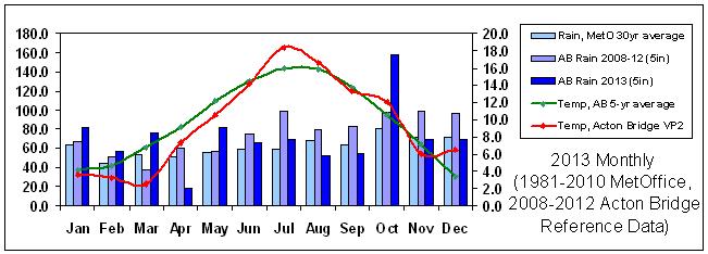
Wettest Day 24. September with 33.8mm
Wettest Month December with 168.4mm
Driest Month March with 20.6mm
Mean Temperature was 9.6°C (just 0.2°C below the 9.8°C 30-year Met Office 1981 to 2010 average). The only months significantly warmer than average were January (+1.4°C) and March (+1.9°C).
Highest Temperature 27.3°C on 24. July
Lowest Temperature -6.0°C on 3. February
Summary of Rainfall and Temperature at Acton Bridge, 2011
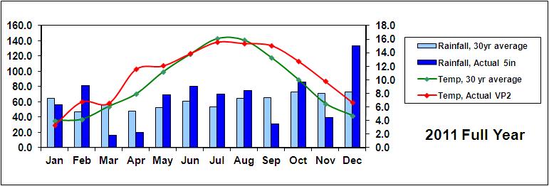
Wettest Day 17.2mm on 22. June
Wettest Month December with 133.7mm
Driest Month March with 16.7mm
Mean Temperature was 10.8°C (1.2°C above the 9.6°C 30-year average). January, July and August were slightly cooler than average, but every other month was above average, especially April (+3.7°), October (+2.7°) and November (+3.3°).
Highest Temperature 28.2°C on 1. October - it must be very unusual for the hottest day of the year so far to occur so late
Lowest Temperature -6.5°C on 29. January
Monthly commentaries for 2011
Rainfall and Temperature at Acton Bridge, January to December 2010
December was an exceptionally cold month, setting records in several parts of the UK, particularly in Northern Ireland. We recorded a remarkably low overall mean at our station of - 0.8°C, more than five degrees below the 30-year average ; five night-time minima below - 10°C ; and, more unusually, some very low day-time maxima, such as - 5.3°C on the 20th, leading to a 24-hour mean temperature of - 9.3°C. The temperature remained below freezing from the 18th to the 25th inclusive, except for a brief max of +0.2°C on the 21st, and the mean on Christmas Day was a bitter - 9.8°C.
Wettest Day 21.4mm on 20. July
Wettest Month August with 94.1mm
Driest Month May with 23.5mm
Mean Temperature was 8.8°C (0.8°C below the 9.6°C 30-year average). January and February (and especially December, as above) were colder than the average, whereas June was significantly warmer.
Highest Temperature 29.3°C on 23. May
Lowest Temperature - 13.9°C on 7. January
Rainfall and Temperature at Acton Bridge, 2009
Rainfall and Temperature at Acton Bridge, 2008
Here are links to our summary statistics page and most recent observations.
Back to Meteo Index Page
Website ©
Steve & Judy Pardoe
Cheshire, England

[Site directory]
[Pardoes' Home page]