Version of 7. December 2023, with links updated [previous one was 21. December 2004: link to another (winter) report]
This is our trip report from July 2001, when we attempted part of the Walkers' Haute Route between Chamonix and Zermatt, in the Swiss Alps.
You may also wish to read our clockwise
1999 Tour du Mont Blanc trip report.
| Judy and I gave the WHR our best shot, but it wasn't good enough. Bad weather and excessive snow made it a lot harder than we'd expected (and certainly a lot harder than the Tour du Mont Blanc, which we'd completed twice), and we packed it in at La Sage after five days. We were also not as fit as we should like to have been, partly because of the Foot and Mouth Disease restrictions in the UK. And we're getting older (109 yrs between us at the time).
This may seem like sour grapes, but even in good conditions we don't think the WHR would be a patch on the TMB for its route, scenery or sense of style; so we don't (at present) feel we missed too much. What's more, there are (even allowing for the bad weather and snow we had) quite a few sections of the WHR which are significantly more exposed than what you generally find on the TMB. Even the relatively benign section between the Cabane du Mont Fort and the Col Termin requires neat and attentive footwork, and the evidence of new chains in several places suggests that the local authorities agree. |
 Lac Bleu, near Arolla, the sky for once matching the name
|
Do get an up to date edition of (the late) Kev Reynolds's guidebook, if you possibly can, as the old one we had (2nd Edition, 1995) was seriously out of date. And it might be worth paying a premium for the yellow cover versions of the Swiss maps with footpaths marked in red, as we found the basic green ones hard to read in poor light (which tends to be when you need to).
If you are interested in the etiquette of using the mountain refuges, you can find some information here.
As we'd already done the Tour of Mont Blanc in both directions, we decided to skip the first three days of the WHR, which duplicate it, and start in Champex. We first drove to Täsch (below Zermatt), leaving the car where we hoped to finish, and took three trains and a bus to Champex. You can book the whole journey on one ticket at Täsch station. We started off from Champex after lunch (on Friday 13th of July), and walked comfortably down to Sembrancher, and then on to Le Châble, staying at the Pension la Ruinette (027 776 1352, 45.- SFR demi-pension).
Next day was all uphill, to the Cabane du Mont Fort, and the unfamiliar weight of our packs really made itself felt. This hut is being extensively rebuilt, and although I'd phoned (027 778 1384) some time previously to make a reservation, we were greeted on the approach by signs saying it was pointless to go up there, as we wouldn't be able to stay. Another phone call confirmed that we could in fact stay (and eat), but we found the only washing facility was an outside trough, not ideal after a midnight bio-break.
 Judy negotiating a chained section on the approach to Col Termin |
Getting across the three cols from Cabane du Mont Fort to the Prafleuri was an epic we'd prefer to forget. The Col Termin was fine, but rain and heavy snow made the descent from Col de Louvie pretty dreadful, and by the time we reached the Grand Désert it was awash with glacier melt, and the path was very hard to find. We kept falling through the soft snow into the rocks beneath, sometimes quite painfully, and once or twice coming close to breaking a leg. |
Once across the Grand Désert, the snow was even deeper, and we found ourselves at the top of a cornice, with no obvious way down other than an uncontrolled drop. We could see that someone had already done this, so I took off my pack and went for it, landing heavily but safely at the top of a small rock cliff. I was just turning round, to ask Judy to send the pack down, when she came flying down beside me, a little sooner than either of us expected. Fortunately, she had kept hold of her walking pole, and we were able to use this to reach my pack and hook it down. Getting off the cliff and safely down the snow slope beyond it required some Scottish Winter Skills which I hadn't expected to need on my summer holiday. We picked up a Sigg bottle and some other debris from which the previous party had been parted, so they obviously had a hard time, too.
 Judy crossing the Grand Désert, and a general view of the lakes and icebergs : yes, this is in mid-July, 2001 |

|
 Judy descending the snow steps which Steve kicked. You can just see the cornice above the rock band
|
It was getting pretty late, thundering hard, and very misty, by the time we breasted the final Col de Prafleuri, and it was with some relief that we stopped climbing and wandered down to the Cabane. Or, to where we thought it should be, but we couldn't find it in the gloom! The new cabane (027 207 3067) is just across a little metal bridge, and up a steep slope, but we were almost at the door before we saw it. Our labours were rewarded by a warm welcome, and a clean dortoir to ourselves. However, as new as it is, the cabane had nowhere warm to dry our soaking boots and clothes. |
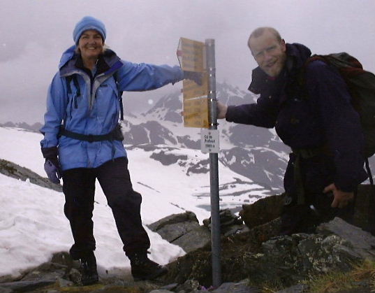 Judy and Steve at the Col de Prafleuri, even managing a smile for the camera. I don't know why this area is called Prafleuri, as there's nothing very flowery about it (apart from my language, when I kept falling over)
|
| The night was very cold, and next morning there was about 10cm of new snow everywhere. Despite this, the hut warden assured us that the crossing of the Col des Roux would be no problem, so we decided to give it a try. Getting up to it was surprisingly easy, but getting down the other side, where the new snow was a lot deeper, took more care, and we were glad of the footprints of three other parties, a Briton, two Russians, and also those of six Dutchmen, who'd set out much earlier that morning. |
 The view looking south from Col des Roux, across Lac des Dix towards Col de Riedmatten (before the weather closed in again)
|
The walk along Lac des Dix was pleasant, and we had a quick snack break at the unmanned but attractive-looking chalet of La Barma. The suspension bridge was not too scary, but things got a lot harder once we started rising into the valley of the Glacier de Cheilon. Here, the path traverses steep slopes, winding in and out along the hillside, and the combination of wet snow on grass and mud is not a happy one. Again, we were glad of footprints to follow, where we could see them, but they were easy to lose in the frequent and sometimes awkward boulder fields.
The guidebook and map suggested that the Col de Riedmatten should be easy enough to find, but once again the mist came down, and we couldn't see any sign of it. We tried a number of couloirs, one of them choked with very unstable new debris, but failed to find evidence of the col or recent prints. It was far too cloudy to see as high as the ridge, anyway. We were sure we'd gone too far south, and were starting to get seriously worried, when we spotted some walkers heading in what could only be the direction of the Cabane des Dix. A forced night there seemed to be the only option, until we happened to hear some metallic clanking on the wind, and soon afterwards some voices, which seemed to be American and Dutch. At last, the cloud lifted slightly and we spotted a figure on the skyline, and realised that we must be approaching the Pas de Chèvres, and its intimidating iron ladders. We'd hoped to avoid this barrier, but now it seemed a blessing.
A massive effort got us up the boulders and scree to the foot of the ladders just in time to catch the last of the Dutch party, and beg the support of their rope. Although they'd set out well ahead of us, they had been delayed at the ladders by a large party of Americans, led by a French Guide from the Chamonix bureau, who had also failed to find the Col de Riedmatten.
 Judy ascending the second of the two iron ladders at the Pas de Chèvres. You have to step from one to the other about two thirds of the way up: easy when fresh and in the dry, rather harder in these conditions. The total height is about 22m (say 70 feet)
|
A quick bowline round the torso would have given us the confidence we needed to tackle the ladders in our mentally and physically shattered state, but the Dutch guys generously insisted on lowering harnesses for us, and so the climb was really very easy. Not long after us, the two Russians arrived, just about done in after even more of an epic than we'd had. |
Once at the top, it was a mere two hours of easy stumbling down to Arolla. Sadly, waiting to help us and the Russians had made the Dutch party miss the last bus to La Sage: we offered to pay for a taxi for them, and/or a beer, but they were able to get a lift in the French Guide's minibus. We picked the first hotel we found in the village itself, which was the Hotel du Glacier (027 283 1218, very agreeable, but rather expensive at 92.- SFR demi-pension).
Next day was supposed to be an easy one, high along the left (west) side of Arolla valley on a delightful, if rather undulating, path to Lac Bleu; and then down to Les Hauderes for lunch, before the pull up to La Sage. We found this quite tiring, after the previous two days, and spent the night here, postponing a decision on continuing the walk until the morning. I'd already made a reservation at the next halt, the Cabane de Moiry (027 475 4534), and had also established from the guardian that the rather more direct Col du Tsate is preferable to the Col de Torrent as the route from La Sage. It certainly seemed more logical on the map, and indeed this is also now Kev Reynolds's recommendation.
In La Sage, we stayed in a rather run-down dortoir at Les Ecureuils, the only accommodation available, but cheap at 47.- SFR demi-pension (027 283 1138). It's actually a huge place once you get inside, a regular rabbit-warren of rooms (mixing metaphors a bit, as "écureuil" translates to squirrel), so finding space was no problem, and we had a choice of rooms to ourselves.
Next morning dawned wet and misty, and our decision to pack it in was easy and mutual. We just couldn't see any joy in a further two wet, cold and tiring days of slogging over cols to Zinal, with no views, and no prospect of much improvement in conditions before Zermatt. The logical step was to phone the Moiry and cancel, grab the Postbus to Sion, and return to Täsch by train.
We're not quitters by nature, but this time it was remarkably easy to stop. Once back at the car, we headed south to Provence, and had a lovely sunny week there, before returning to the Alps around Megève for some walking, this time without such heavy packs.
We had some links here to other Walkers' Haute Route and related pages, but (in 2023) only one remains, offered without responsibility, of course:
Michael Cunningham with a great set of photos from summer 2002
Kev Reynolds Obituary at Cicerone
There are also lots of commercial tours, try searching
Google and you'll get loads to choose from.
Website ©
Steve & Judy Pardoe
Cheshire, England |

|
 |
 |
| [Climbing Index Page] |
[Site directory & e-mail] |
[Home page] |